Google has just re-designed, revamped and re-launched its Earth product, and it has certainly been worth the two-year wait.
Earth is now built into Chrome, so there is no longer a need to download a cumbersome desktop app to access this global repository of images, videos, and knowledge cards.
The Android app has been updated too, with support to follow soon for mobile browsers and iOS.
So what’s new?
A lot.
First impressions of Earth are simple: this is a hugely impressive feat, one that truly celebrates the world – both natural and man-made – by capturing its farthest corners in finite detail.
So, let’s get started. We begin with a zoomed-out view of the planet, before a short introduction from Google on some of Earth’s upgraded features.
These features work in a cumulative fashion, each adding to the last and building up to three-dimensional, customizable, multimedia experience of our planet.
First up, the search function. The foundation of any great Google product, this deceptively simple search bar leads to any location in the world:
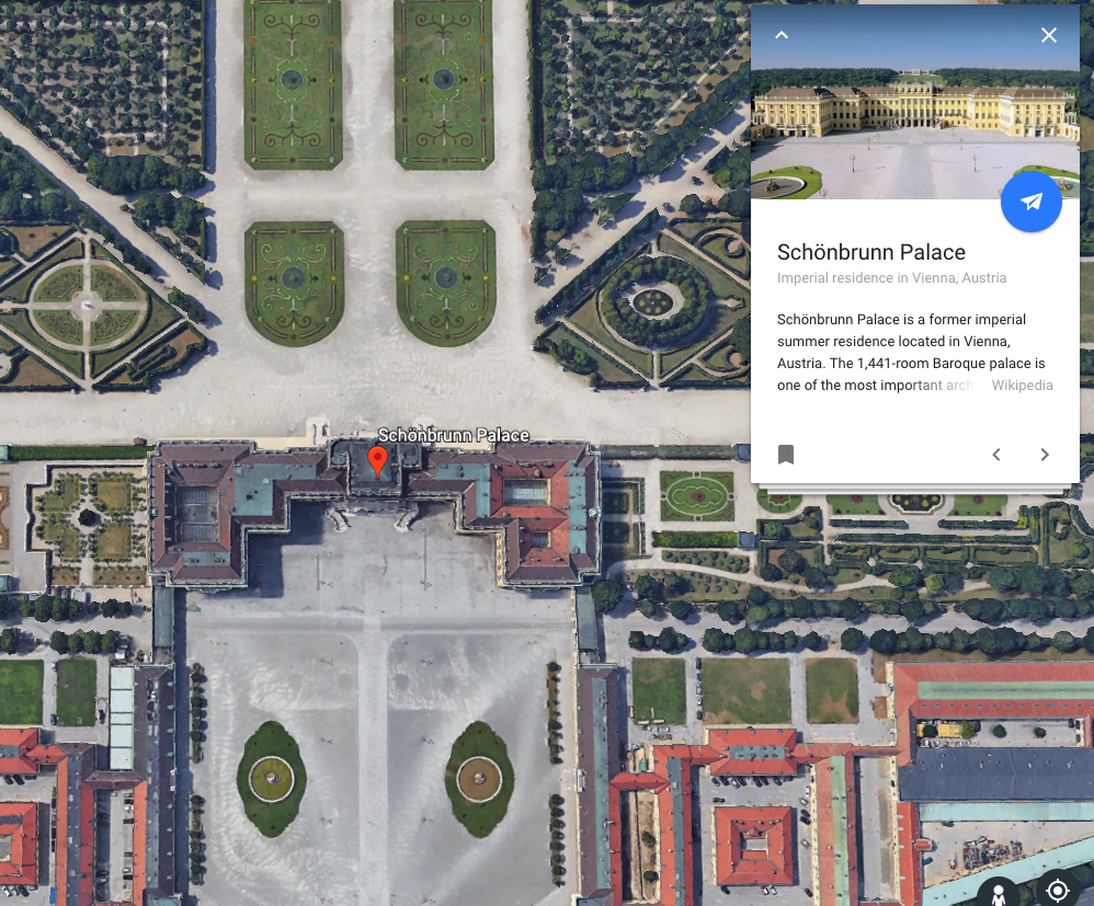
This is given extra potency when combined with Google’s vast inventory of knowledge cards about cities, rivers, buildings, and basically just about any landmark you can think of.
These are typically pulled from Wikipedia and appear as a clickable carousel, although other resources are cited on infrequent occasions.
It is possible to zoom in to the level of Google Street View to get a closer look at the palace in this screenshot, as has been available via Earth and Maps for some time now. This is labeled the ‘Photo Sphere’.
Added to this is the “I’m Feeling Lucky” feature, which takes the user to a random point on the map and works like the button of the same name in traditional Google search.
My first trial of “I’m Feeling Lucky” took me from Lagos to Legoland in just one click. It can be quite a dizzying trip, depending on your screen size and propensity for motion sickness, but the speed of flight can be adjusted in the settings menu.
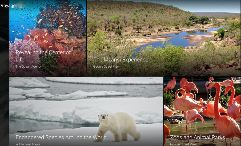
Layer by layer, this builds up to Voyager, the section most likely to keep users engaged with Google Earth.
Voyager contains a wealth of curated content from sources as diverse as Sesame Street and the BBC, but we should expect many more publisher partnerships in future.
This is significant, as it takes Google into the realm of visual storytelling and opens up a host of new opportunities for publishers willing and able to get on board.
There is already a good variety of content on here, including city guides, nature trails, and the work of specific architects like Frank Gehry. That said, this is an inexhaustible resource that will play host to a lot more experimentation soon.
One highlight is the ‘Revealing the Center of Life’ tour, which takes us on a journey underwater to explore coral reefs.
As an educational center, this offers unparalleled scope for exploration and will undoubtedly spark much healthy discussion. Some of these knowledge cards are accompanied by videos and behind-the-scenes features too, providing further context to the images.
The implications for marketers
Brands should really be thinking about how to avail of the storytelling possibilities that this brings. For travel and tourism companies the opportunity is perhaps a little more obvious than for other industries, but in truth there is an opening here for almost everyone.
The Argentinian artist Federico Winer has partnered with Google to create a photographic series on airports, for example.
There is also a history tour that traces the steps of characters in the novels of Charles Dickens, and another that visits some of Ernest Hemingway’s favorite haunts.
With consumer attention spans at an all-time low, Google Earth should now be viewed as an incredibly powerful, engaging tool, should publishers have the imagination to avail of its potential.
In perhaps more prosaic terms, local search remains just as vital as it has been for some time now – perhaps even more so.
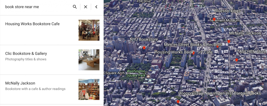
Typical searches like the one below for [book store near me] will bring up an interactive 3D map of the local area with some options, so it is vital to have business names, addresses, opening hours, photos, and phone numbers up to date.
Customizing Google Earth
And it doesn’t stop there. Users can import KML (Keyhole Markup Language) files to overlay images and charts onto Google Earth. Google even provides an example of this in action, with an overlaid image of Mount Etna erupting.
KML is based on the XML standard and provides a few extra functionalities, like paths and polygons, that are particularly useful for Google Earth.
Google provides a sample file and comprehensive guide to get started, although this should be pretty familiar to anyone accustomed to creating custom Google Maps.
In summary
The new Google Earth is more than the sum of its features; at its best, it can both distort and inform our perception of space and time.
A historical echo of this project would be the eighteenth-century Encyclopédie, a Herculean effort by Denis Diderot, Jean le Rond d’Alembert, Voltaire, and many others, to catalogue and categorize all human knowledge.
Combine that persistent thirst for knowledge with the technology at Google’s disposal and the product is something as engrossing and enlightening as the new Google Earth.
It seems fitting to give the final word to Google:
source https://searchenginewatch.com/2017/04/20/whats-new-with-earth-first-impressions-of-the-relaunched-google-earth/


No comments:
Post a Comment